


Territory Planning
– Service zoning optimization
Service territory planning, also known as sales territory planning or optimization, is a widely used practice in sales and marketing. When dealing with a large market and multiple sales teams, it's often necessary to divide the market into territories and assign each territory to a sales team. However, dividing the market into territories that meet specific criteria, such as an equal amount of workload and/or travel expenses, can be a challenging task.
Fortunately, we have developed a unique optimization program that can relieve you from the complexities of service territory planning. Our program helps clients optimally allocate their sales and service resources to maximize productivity. The framework for service territory planning may include the following:
- Mapping the spatial pattern of the services/sales workload
- Determine the number of service/sales teams needed for the target market
- Define specific criteria for the territory partition
- Search the optimal service/sales territory partition which best fulfill the predefined criteria

What is the total workload of the target market?
How many service/sales teams do we need for target market?
Which one of our current teams have overwhelmed/insufficient workload?
The planning application developed by our team can accommodate any specific requirements that clients may have. For example:
- Uneven workload for different service territories
- Special requirements for territory boundaries, e.g., following jurisdictions’ boundaries, major roads
Get In Touch
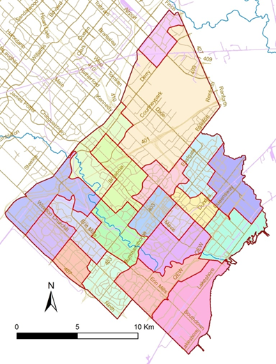
Example of Service territory optimization --- Service territory planning in Mississauga Ontario
In this demonstration, we will illustrate how service territory planning works, using the City of Mississauga as our example. Our target market is the entire population of the city. To effectively serve this market, we have developed three criteria for our service territory planning:
- Workload balance: To ensure that our teams are able to deliver services efficiently, we will divide the market into 20 service territories, each corresponding to a service/sales team.
- We will aim to balance the workload across these territories by ensuring that each has an equal population size.
- Geographic boundaries: To ensure that our teams are able to navigate the their territories efficiently, we will design territory boundaries that follow major roads, rivers, and railways.
By incorporating these criteria into our service territory planning, we aim to efficiently serve the entire population of Mississauga. However, in reality, there may be conflicts between our second and third goals, which may require us to make some trade-offs between them.
Maintaining a balance between different criteria and maximizing clients’ satisfaction can be extremely difficult. To overcome this challenge, we have developed an advanced optimization tool that helps us solve complex problems easily and efficiently.
We used the 2016 census data, as well as other base information such as roads, rivers, and railways, to inform our planning process. Through a series of advanced spatial analyses and automated optimization simulations, the program evaluated millions of territory planning scenarios and identified the best solution: dividing the City of Mississauga into 20 service territories with a workload variation of less than 6% (see the map on the right-hand side).
This process allowed us to balance our workload across different service territories while ensuring accessibility and efficiency. By leveraging advanced technology and data-driven insights, we can continue to optimize our service territory planning and deliver exceptional service to our customers.
Our team has developed the entire framework for service territory planning, which allows us to customize the application to meet any specific requirements from our clients. For instance:
- Workload customization: We can specify the workload of each service territory, rather than using an average value.
- Predefined boundaries: We can allow our clients to predefine any roads, rivers, or railways to be used as boundaries during the territory optimization process.
- Fixed boundaries: Our framework allows for the predefined designation of certain areas as a single territory with fixed boundaries before the optimization process.
With these customizable options, our framework provides the flexibility to meet the unique needs of each of our clients. By collaborating with our clients and leveraging their input, we can optimize service territory planning to achieve the best possible outcomes for their specific circumstances.
We are Expertise in

Data Analytics
Find the story behind the data, better vision to your business

Site Selection
A smart choice of retailer geographical location

Data Management
Optimize your data structure, standardize data profile, integrate your data seamlessly

Artificial Intelligence
Save the resources by automate the business process
Data Visualization
Intuitively tell the story to your clients

Territory Planning
Optimize your market zones and team structure
Only one more step is needed to Your Success: